-
Faculty of Arts and HumanitiesDean's Office, Faculty of Arts and HumanitiesJakobi 2, r 116-121 51005 Tartu linn, Tartu linn, Tartumaa EST0Institute of History and ArchaeologyJakobi 2 51005 Tartu linn, Tartu linn, Tartumaa EST0Institute of Estonian and General LinguisticsJakobi 2, IV korrus 51005 Tartu linn, Tartu linn, Tartumaa EST0Institute of Philosophy and SemioticsJakobi 2, III korrus, ruumid 302-337 51005 Tartu linn, Tartu linn, Tartumaa EST0Institute of Cultural ResearchÜlikooli 16 51003 Tartu linn, Tartu linn, Tartumaa EST0Institute of Foreign Languages and CulturesLossi 3 51003 Tartu linn, Tartu linn, Tartumaa EST0School of Theology and Religious StudiesÜlikooli 18 50090 Tartu linn, Tartu linn, Tartumaa EST0Viljandi Culture AcademyPosti 1 71004 Viljandi linn, Viljandimaa EST0Professors emeriti, Faculty of Arts and Humanities0Associate Professors emeriti, Faculty of Arts and Humanities0Faculty of Social SciencesDean's Office, Faculty of Social SciencesLossi 36 51003 Tartu linn, Tartu linn, Tartumaa EST0Institute of EducationJakobi 5 51005 Tartu linn, Tartu linn, Tartumaa EST0Johan Skytte Institute of Political StudiesLossi 36, ruum 301 51003 Tartu linn, Tartu linn, Tartumaa EST0School of Economics and Business AdministrationNarva mnt 18 51009 Tartu linn, Tartu linn, Tartumaa EST0Institute of PsychologyNäituse 2 50409 Tartu linn, Tartu linn, Tartumaa EST0School of LawNäituse 20 - 324 50409 Tartu linn, Tartu linn, Tartumaa EST0Institute of Social StudiesLossi 36 51003 Tartu linn, Tartu linn, Tartumaa EST0Narva CollegeRaekoja plats 2 20307 Narva linn, Ida-Virumaa EST0Pärnu CollegeRingi 35 80012 Pärnu linn, Pärnu linn, Pärnumaa EST0Professors emeriti, Faculty of Social Sciences0Associate Professors emeriti, Faculty of Social Sciences0Faculty of MedicineDean's Office, Faculty of MedicineRavila 19 50411 Tartu linn, Tartu linn, Tartumaa ESTInstitute of Biomedicine and Translational MedicineBiomeedikum, Ravila 19 50411 Tartu linn, Tartu linn, Tartumaa ESTInstitute of PharmacyNooruse 1 50411 Tartu linn, Tartu linn, Tartumaa ESTInstitute of DentistryL. Puusepa 1a 50406 Tartu linn, Tartu linn, Tartumaa ESTInstitute of Clinical MedicineL. Puusepa 8 50406 Tartu linn, Tartu linn, Tartumaa ESTInstitute of Family Medicine and Public HealthRavila 19 50411 Tartu linn, Tartu linn, Tartumaa ESTInstitute of Sport Sciences and PhysiotherapyUjula 4 51008 Tartu linn, Tartu linn, Tartumaa ESTProfessors emeriti, Faculty of Medicine0Associate Professors emeriti, Faculty of Medicine0Faculty of Science and TechnologyDean's Office, Faculty of Science and TechnologyVanemuise 46 - 208 51003 Tartu linn, Tartu linn, Tartumaa ESTInstitute of Computer ScienceNarva mnt 18 51009 Tartu linn, Tartu linn, Tartumaa ESTInstitute of GenomicsRiia 23b/2 51010 Tartu linn, Tartu linn, Tartumaa ESTEstonian Marine Institute0Institute of PhysicsInstitute of ChemistryRavila 14a 50411 Tartu linn, Tartu linn, Tartumaa EST0Institute of Mathematics and StatisticsNarva mnt 18 51009 Tartu linn, Tartu linn, Tartumaa EST0Institute of Molecular and Cell BiologyRiia 23, 23b - 134 51010 Tartu linn, Tartu linn, Tartumaa ESTTartu ObservatoryObservatooriumi 1 61602 Tõravere alevik, Nõo vald, Tartumaa EST0Institute of TechnologyNooruse 1 50411 Tartu linn, Tartu linn, Tartumaa ESTInstitute of Ecology and Earth SciencesJ. Liivi tn 2 50409 Tartu linn, Tartu linn, Tartumaa ESTProfessors emeriti, Faculty of Science and Technology0Associate Professors emeriti, Faculty of Science and Technology0Institute of BioengineeringArea of Academic SecretaryHuman Resources OfficeUppsala 6, Lossi 36 51003 Tartu linn, Tartu linn, Tartumaa EST0Area of Head of FinanceFinance Office0Area of Director of AdministrationInformation Technology Office0Administrative OfficeÜlikooli 17 (III korrus) 51005 Tartu linn, Tartu linn, Tartumaa EST0Estates Office0Marketing and Communication OfficeÜlikooli 18, ruumid 102, 104, 209, 210 50090 Tartu linn, Tartu linn, Tartumaa EST0Area of RectorRector's Strategy OfficeInternal Audit OfficeArea of Vice Rector for Academic AffairsOffice of Academic Affairs0University of Tartu Youth AcademyUppsala 10 51003 Tartu linn, Tartu linn, Tartumaa EST0Student Union OfficeÜlikooli 18b 51005 Tartu linn, Tartu linn, Tartumaa EST0Centre for Learning and TeachingArea of Vice Rector for ResearchUniversity of Tartu LibraryW. Struve 1 50091 Tartu linn, Tartu linn, Tartumaa EST0Grant OfficeArea of Vice Rector for DevelopmentCentre for Entrepreneurship and InnovationNarva mnt 18 51009 Tartu linn, Tartu linn, Tartumaa EST0University of Tartu Natural History Museum and Botanical GardenVanemuise 46 51003 Tartu linn, Tartu linn, Tartumaa EST0International Cooperation and Protocol Office0University of Tartu MuseumLossi 25 51003 Tartu linn, Tartu linn, Tartumaa EST0

Project "GlintMapper"
Resolving near-coastal remote sensing signal into contributions by bottom, water column, glint and the adjacency effect
Acronym: GlintMapper
ESA contract: 4000144012/24/I-DT-bgh
Duration: 01.05.2024 – 31.10.2025
Project leader: Martin Ligi
Social media: #ESA_GlintMapper
Project description:
All waterbodies are changing in the variable climate conditions. Monitoring of these changes over large areas is possible only by using remote sensing. However, remote sensing of lacustrine waterbodies is hampered by the nearby land as part of the signal measured above the waterbodies originates from the nearby land not from the water itself. This problem, called the adjacency effect, is detectable up to kilometers from the shore. In the case of majority of lakes on Earth it means that every water pixel is affected by the nearby land. Moreover, the signal measured near the shores may contain effects from the bottom (if water is optically shallow), signal from emerging vegetation, sun and sky glint. In the case of marine remote sensing these problematic areas are usually masked out in remote sensing studies as too complicated to resolve. This is not an option in lake remote sensing as just a few tens of lakes (out of 117 million) are large enough to contain pixels free from the adjacency and other coastal effects. Moreover, up to 99% of carbon is processed in the near-shore waters and never reaches the deep ocean carbon pool. Thus, many important processes take place in the near-coastal waters that are currently masked out from remote sensing imagery as too complex to resolve. This limits the use of remote sensing in environmental research and monitoring.
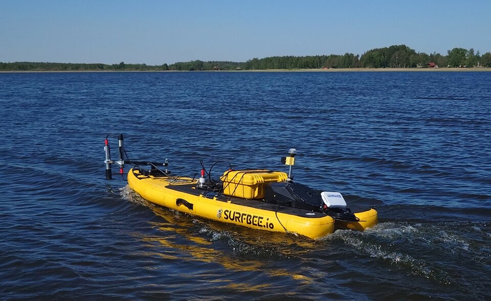
Our aim is to study the very nearshore waters in order to resolve the contribution of the adjacency effect, lake/sea bottom, sun and sky glint and the water column itself and develop algorithms for removing the adjacency effect and glint from Sentinel imagery. We have an unmanned surface vehicle equipped with radiometers, fluorometers, sonar, underwater and in-air video cameras. This package allows us to make high frequency reflectance measurements almost from the shore (from 20 cm water depth) to open parts of lakes and coastal waters and assess the contributions of bottom, water column, glint and the adjacency effect on the water reflectance. The contribution of adjacency effect in the remote sensing signal depends on the contrast between the (dark) water and (bright) land. Therefore, we will carry out experiments in lakes with different optical water properties and during different season (i.e. different brightness of land). For example, in dark CDOM-rich lakes most of the remote sensing signal in visible part of spectrum is due to glint and the adjacency effect while in shallow waters with bright bottom or in lakes with massive phytoplankton blooms the adjacency effect and glint may be parameters that have nearly negligible effect on the remote sensing signal.
In the end, we will propose a methodology how to resolve different components in the remote sensing signal measured near shores of lakes and seas. This will allow to make significant step forward in studying properties and processes in near-coastal waters and lakes that are currently not studied with remote sensing because the areas are flagged, or masked out completely, due to their optical complexity.